
The further development of local policies to stimulate more CO2-productivity in city logistics and a shift to zero-emission city logistics is inevitable: growing political and societal pressure demands it. This push can already be recognized in the existing variety of local regulations, customized to different local circumstances in different cities or parts of cities.
Policy regulations
Policy regulations such as low emission zones (limiting access to vehicles better than a certain emission standard), limited access times for freight transport in city centres (for instance between 6 and 11 a.m.), axle-weight limitations or length limitations are all standard practice today. Some cities now limit access entirely in certain districts.
These policy regulations are contentious as they are generic, impact supply chains directly and are feared by transporters to be subject to sudden changes after elections. Yet some form of regulation is highly desirable.
Regulating access: performance based
There is a growing need for a more flexible and customizable method of regulating access. As connected vehicles with geolocation capabilities are becoming standard, the path to individualized regulation is opened, the next step going beyond current regulatory practice.
The term ‘performance-based regulation’ describes a highly flexible and individualized approach to regulating why, when and where a commercial vehicle can drive. The word ‘performance’ is used both for roads and the immediate environment (how sensitive is the situation, like children playing nearby, how much weight can a bridge carry, how sensitive is the environment to air pollution and noise) as well as for the vehicle (weight including cargo, size, emissions, noise, safety features, etc.).
Performance-based regulation is about matching vehicle performance to the sensitivity of the environment. This may be time-of-day-dependent, as with noise emissions, for example. The assumption is that vehicles are GPS-enabled and connected and can therefore be transparent to regulators, allowing access to be customized.
The generic term ‘city’ is a container concept, describing a large variety of urban areas. The dense old city centre of Amsterdam, for example, poses quite different challenges to the more recent open structure of Rotterdam. A suburban area does not have the same frequency of delivery as a pedestrian area with shops. Size and therefore volume of deliveries make solutions possible that cannot be economically sustained in smaller cities.
This flexibility is created by combining a common framework for various levels of regulation (in geo-fenced zones) with local implementation at the levels required.
Such a framework would make it easier and more attractive for cities to implement regulations and ensure that these are more harmonized across cities. This well help create the scale required for low-cost implementation. The standardization created by adopting a common approach allows for scale, low costs and ease of use for supply networks servicing the entire country, with specific local circumstances driving how the framework of zones is applied locally (and changes over time).
Zoning
A choice of zones and applicable regimes might be as follows (in rising order of regulation level):
- Public roads : no other regulations
- Geo-fencing : for instance based on emission class b. or with time windows
- Routed geo-fencing : as 2, but with addition of prescribed/limited routes to (un)loading zones
- Slotted and routed geofencing:. as 3, with the addition of allocated timeslots for entry and (un-)loading-zones b. assumes advanced ITS systems that create ‘green-flow’ with priority, and managed unloading zones (reserved, with flexibility in trading slots between users)
- Restricted : for designated modes of transport and designated routes only
An example of level 5 would be the construction challenge posed by the large ‘Marine’ site in Amsterdam. The only acceptable mode here might be an (electric) at barge commuting between the north of the IJ river, where the consolidation centre is, pre-fab components are constructed and heavy machinery is maintained, and the site itself where construction takes place.
Level 4 is quite well known in Distribution Centres for large retail organizations, where this is standard practice (except the possibility of trading slots between transporters). As such, this is not new or uncommon, it just has not been applied to dense city centres.
Connected commercial vehicles that are transparent on cargo and destination(s) allow for easy implementation of zones and cheap, flexible and easily re-tuned individualized regulation. The choice of zones, where they are useful and if they should be used at all would be a local decision fitting the local circumstances.
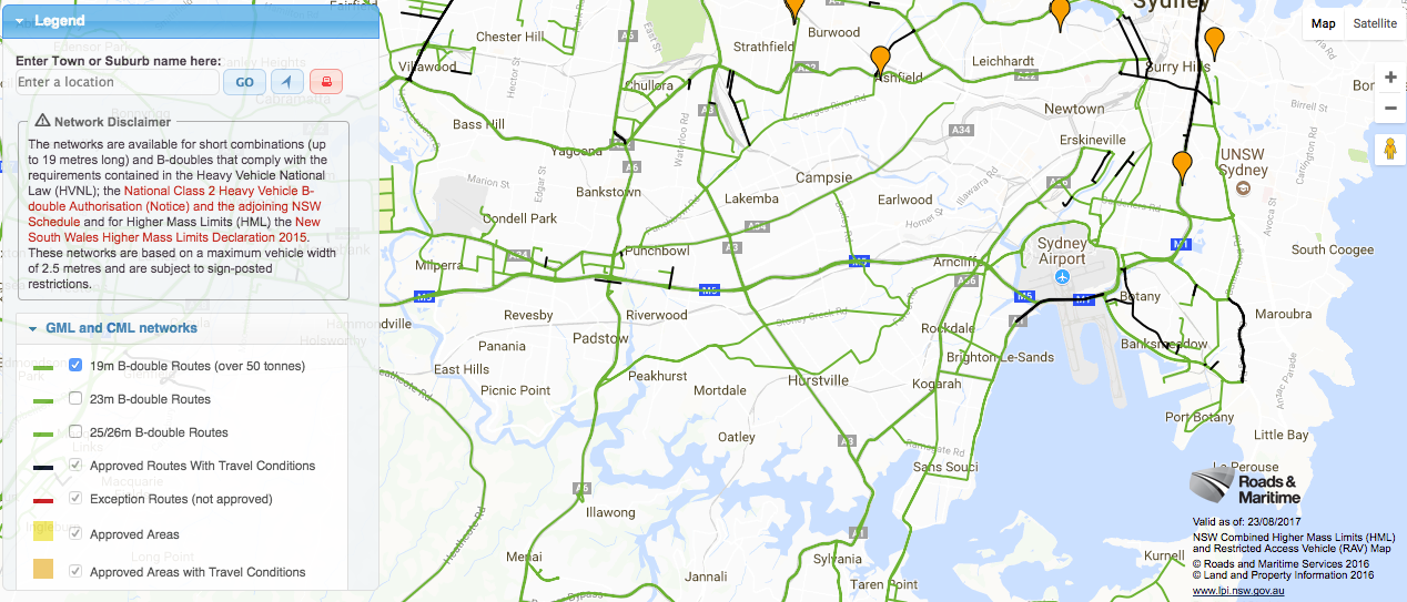
Australian Intelligent Access Program
The Australian Intelligent Access Program (IAP) is a national program whereby heavy vehicle operators agree to remote tracking of the movement and location of their vehicles. This ensures they are complying with agreed operating conditions, in return for access or less restrictive access to the road network. IAP is a vehicle tracking system used to monitor heavy vehicles that may damage road infrastructure and/or pose road safety risks. Vehicles are monitored to ensure they adhere to approved routes, at approved times and are not operating on inappropriate roads. The Intelligent Access Program (IAP) commenced in Victoria in November 2008.
Source: Annual Outlook Citylogistics
[…] aan vervoerders die kunnen aantonen dat ze gebundeld of emissievrij bevoorraden. Deze zogenoemde ‘Performance Based Regulation’ kan op termijn leiden tot een besparing van zeker 20 procent aan vracht- en bestelkilometers in […]
[…] over transport en verkeersdata delen. De overheid kan de bouwers vervolgens ondersteunen met ‘intelligent access’ en verkeersdata voor een betere doorstroming. Bij intelligent access delen ondernemers data met […]
[…] van venstertijden, gebruik van busbanen en toegang tot zero-emissie laad- en losplekken; intelligent access. Verkeersmanagementsystemen kunnen de reguliere en digitale handhaving ondersteunen. De publieke […]
[…] gebied Oudezijde alleen toegankelijk voor bewoners en voor mensen die in het gebied moeten zijn. Intelligente toegang is een techniek die meer mogelijkheden biedt bij het verlenen van toegang aan verschillende groepen […]
[…] van venstertijden, gebruik van busbanen en toegang tot zero-emissie laad- en losplekken; intelligent access. Verkeersmanagementsystemen kunnen de reguliere en digitale handhaving ondersteunen. De publieke […]