
Picnic is an online, mobile, and app-only supermarket providing affordable grocery shopping with free delivery in the Netherlands, Germany, and France. Picnic respects their customers’ time and aims to provide a service reflecting that. They guarantee to deliver groceries during a one-hour delivery window selected by the customer between one day and one week ahead.
On the day of delivery, Picnic communicates a more narrow 20-minute window. And this is only the first step in keeping the customer up-to-date. In the Picnic App customers can track delivery in real-time using the Delivery Radar. Picnic’s Aliaksandr Sasnouskikh explains how it works.
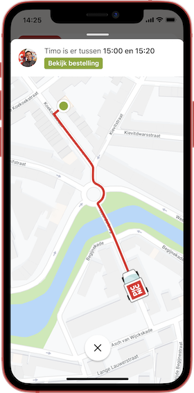
Picnic customers can track the delivery vehicle on the Delivery Radar. This map shows the progress of the delivery from the Picnic hub (the local Picnic warehouse from which the vehicles depart) to their address. On the map, the current location of the vehicle, its route, and the expected time of arrival at the destination are displayed. And all that is updated in real-time.
The photo and the name of the Picnic delivery person (so-called runner) is displayed as well so that the customer knows who will deliver their groceries today. Once the vehicle arrives at the customer’s house the Picnic App plays a car horn signal, notifying of the runner’s arrival even before the doorbell rings.
First of all, the Delivery Radar must be accurate enough to inspire customer trust. But both customer and runner personal data, such as current geolocation and home address, must be secured to ensure privacy and meet GDPR regulations. Secondly, the animation of the vehicle movements should be smooth to keep user experience pleasant. And last but not least, it should support dynamic assets to bring additional functionality to the app and possibilities for business.
When working with event-based communication originating from mobile applications you need to be ready to deal with late, unordered, and missed events caused by connectivity issues, battery outages, sensors’ quality, app user mistakes, etc. To handle such cases Picnic has several fallback levels in the vehicle location calculation logic by using GPS data, Picnic’s Aliaksandr Sasnouskikh explains in his blog.
The Delivery Radar gets Delivery Scenario progress updates on dynamic intervals (decreasing while getting closer to the destination to improve the Delivery Radar accuracy on the last delivery mile) plus communication latency which requires Picnic to make a decision on how the vehicle should move before the new position is known, to keep the movement smooth.